
")
")
")
")
")
")
|
Hopegill Head
There are several ways to make a circuit to Hopegill Head and down (ask Diana for suggestions if you're staying at High Swinside). This one is featured on the Andrewswalks website. It ascends onto the Dodd, then over Whiteside to Hopegill Head. Descent is via Gasgill Gill and so back along the valley. Superb photos with a cloud inversion filling the Lorton Valley. An 8.3 mile circuit for Andrew from near Millers Place, it is more like 9.3 miles from High Swinside but with only 715m of ascent: leave via the cattlegrid and walk south along the lane. Take the footpath on your left to cross Hope Gill, then head up left to join Andrew's ascending path onto the Dodd. Read more...
Ladyside Pike & Hopegill Head
This second Hopegill horseshoe is the most convenient from High Swinside, starting over Swinside fell and Ladyside, the path then crosses the dramatic northwest crags of Hopegill Head. The return route is along the ridge to Whiteside and down the Dodd. Only 5.2 miles from High Swinside with 665m of ascent. Here, Andrew Locking is walking it one beautiful sunny morning in April. From his starting point it is a 7 mile circuit with somewhat more ascent. Read more...
The High Stile Range
The High Stile Range is a classic walk with stunning views over the central fells as well as over the other Buttermere Fells. Walked from Buttermere village it is 8 miles in length and involves 885m of ascent, starting over Red Pike, and finishing down the Scarth Gap path and back along the Buttermere shore. Andrew Locking's website - Andrewswalks.co.uk - has superb photos from when he walked the High Stile range one July...
Grasmoor via Whiteless Pike
This fab route up Grasmoor starts from the Cinderdale car park near Crummock Water and is walked here by the Hileys of Loweswatercam.co.uk in perfect March visibility. Their route starts up through Rannerdale to Whiteless Pike, then on to Wandope and Crag Hill, and finally up onto Grasmoor itself. Their descent is down the Lad Howes path to their start. Total 7 miles with 1006m ascent. You can see their route and stunning photos on the Loweswatercam website.
Grasmoor, Hopegill Head & Whiteside
This Grasmoor horseshoe starts from the Lorton valley with a walk around to the Lad Howes path up to the Grasmoor summit, then circles around over Hopegill Head to Whiteside to descend via the Dodd. These snowy photos were taken by Andrew Locking walking the route in January, wearing microspikes on the tops: length 9.3 miles, with a total ascent of 1097 metres. See and read more on the Andrewswalks website...
Grisedale Pike - from Braithwaite
Fab routes are possible between Braithwaite (or Whinlatter) and the Lorton valley - especially when the Honister Rambler runs from Easter to the end of October so you don't leave a car stranded: eg. Barrow, Sail, Crag Hill, with choices to make at Coledale Hause; or Grisedale Pike from Whinlatter. The possibilities multiply if you use the bus at both ends: Cat Bells to Robinson, Causey Pike to Grasmoor or Whiteless Pike, or Whinlatter to Buttermere village... This superb 7 mile ridge walk from Braithwaite to the Lorton valley is over Grisedale Pike with 840 metres of ascent, finishing close to home at the Dodd. The views are dramatic, and you can see whole walk on andrewswalks.co.uk. |
||||||
|
|||||||
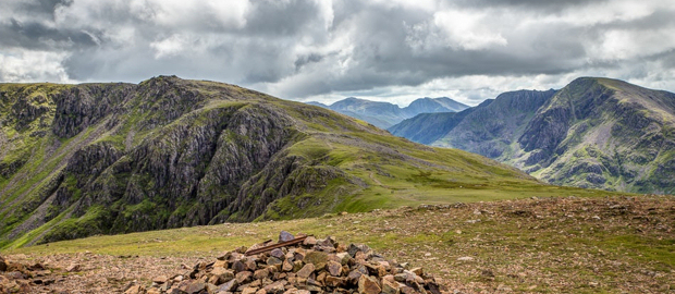
NW Lakeland's High Peaks & Horseshoes
These are the walks that the Lake District is famous for - its highest peaks or several of them strung together to create a glorious ridge walk or horseshoe. The Vale of Lorton has several of them: Grasmoor, Hopegill Head, and Grisedale Pike - individually or each as part of a horseshoe. Robinson, Hindscath, and Dale Head on one side of Buttermere, the High Stile ridge on the other - or string them both together to create a superb challenge for a long summer's day. And when the Honister Rambler is running between Easter and October even more possibilities present themselves - like walking over Grisedale Pike to Braithwaite, or over Hopegill Head to Buttermere - then catching the bus back...
These are the walks that the Lake District is famous for - its highest peaks or several of them strung together to create a glorious ridge walk or horseshoe. The Vale of Lorton has several of them: Grasmoor, Hopegill Head, and Grisedale Pike - individually or each as part of a horseshoe. Robinson, Hindscath, and Dale Head on one side of Buttermere, the High Stile ridge on the other - or string them both together to create a superb challenge for a long summer's day. And when the Honister Rambler is running between Easter and October even more possibilities present themselves - like walking over Grisedale Pike to Braithwaite, or over Hopegill Head to Buttermere - then catching the bus back...
- Generally up to 12 miles in length
- Up to 1000 meters of ascent & descent
- - or more if you do a round or a horseshoe
- Steep ascents & long descents
- Rocky uneven paths & some hands-on scrambling in places
|
|